Precise Measurements Help Gauge Pacific Northwest's Earthquake Potential
 |
M. Meghan Miller1, Herb Dragert2, Elliot Endo3, Jeffrey T. Freymueller4, Chris Goldfinger5, Harvey M. Kelsey6, Eugene D. Humphreys7, Daniel J. Johnson1, Robert McCaffrey8, John S. Oldow9, Anthony Qamar10, and Charles M. Rubin1 |
Abstract
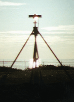
Except for the recent rumblings of a few moderate earthquakes and the eruption of Mt. St. Helen's, all has been relatively quiet on the Pacific Northwestern front. The Cascades region in the Pacific Northwest, a sporadically active earthquake and volcanic zone, still has great seismic potential [Atwater, 1987], as comparisons with other subduction zones around the world have shown [Heaton and Kanamori, 1984]. Recent tsunami propagation models [Satake, 1996] and tree ring studies suggest that the last great Cascadia earthquake occurred in the winter of 1700 A.D. and had a magnitude of ~8.9. The North Cascades or Wenatchee earthquake followed in 1872. With an estimated magnitude greater than 7, it was the largest earthquake in the written history of Washington and Oregon. When will a great earthquake next hit this region, where is it most likely to occur, and what kind of hazard will it present to populated areas? Relatively little is known about specific faults within the deforming continental plate margin, or about the recurrence and dynamics of great Cascadia earthquakes. But a permanent array of Global Positioning System (GPS) receivers in the United States and Canada (Figure 1), many of which were installed last year will help answer these questions by monitoring the subduction zone along the Cascadia margin and providing data for earthquake hazard assessment in the Pacific Northwest.
This geodetic network, operated by the Pacific Northwest Geodetic Array (PANGA) consortium, monitors crustal deformation from accumulating tectonic stress--which ultimately drives damaging earthquakes and presages volcanic eruptions--with millimeter-level precision. Currently, eight GPS receivers in British Columbia and ten in the U.S. are operating under the auspices of the PANGA consortium (Table 1). Network installation and coordinated data analysis began in August, 1997, and results are now available at http://www.panga.cwu.edu/.The network is designed to support geophysical models that resolve the kinematics and dynamics of deformation in the Pacific Northwest. Geodetically constrained modeling will discriminate the relative importance of the various tectonic forces described in detail. In addition, this work will better characterize important crustal faults in Vancouver, Seattle, Portland, and other populated areas that pose seismic risk to the region.
1Department of Geological Sciences, Central Washington University, Ellensburg, WA USA
2Geological Survey of Canada, Pacific Geoscience Centre, Sidney, B.C. Canada
3Cascade Volcano Observatory, U. S. Geological Survey, Vancouver, WA USA
4University of Alaska, Fairbanks, AK USA
5Oregon State University, Corvallis, OR USA
6Humboldt State University, Arcata, CA USA
7University of Oregon, Eugene, OR USA
8Rensselaer Polytechnic Institute, Troy, NY USA
9 University of Idaho, Moscow, ID USA
10University of Washington, Seattle, WA USA
| Eos, Transactions, American Geophysical Union, V. 79, No. 23, June 9, 1998, p. 269-275 (212 K) |