GPS determination of current Pacific-North America plate motion
 |
Kyle Antonelis1, Daniel J. Johnson1, M. Meghan Miller1, and Randy Palmer2 |
Abstract
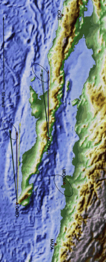
Global Positioning System (GPS) data, collected by campaign-style GPS experiments at five sites along the Gulf of California in 1996 and 1998, determine a locally based estimate for current relative motion between the Pacific and North American plates. At the mouth of the Gulf of California, the Pacific plate moves 50.4 ± 3.4 mm/yr, along an azimuth of N59.0°W ± 2.7°, relative to mainland Mexico. These estimates substantiate and refine previous locally based GPS-determined rates, and agree with GPS determinations of global plate motion. A reexamination of magnetic anomalies in the gulf used in the widely accepted NUVEL-1A global plate model has yielded an average Pacific–North American relative velocity from 0.78 Ma to the present of 51.1 ± 2.5 mm/yr. The new GPS-determined velocity agrees with this estimate, supporting the ideas that the transfer of Baja California to the Pacific plate continued until ca. 1 Ma, and that the current Pacific–North American rate is greater than the 3.16 Ma average. The azimuth determination is 5° west of the NUVEL-1A results calculated from earthquake slip vectors and azimuths of gulf transforms offsetting both oceanic and continental crust. The Tamayo fracture represents the only fault zone used in the NUVEL-1A model that offsets solely oceanic crust. This fault zone trends N60°W, consistent with the GPS-determined azimuth at the mouth of the gulf.
1Department of Geological Sciences, Central Washington University, Ellensburg, Washington 98926 USA
2 Department of Geological Sciences, University of Oregon, Eugene, Oregon 97403 USA
|
|
Geology, v. 27, p. 299-302, 1999 (3.5 MB) |